One of the problems of any technician using
maps is to determine quickly and accurately the numerical value of given
areas. The Polar Planimeter is usually used, but for the field
man, has the disadvantage of being rather cumbersome, expensive, and
subject to breakage. Neither of these objections occur in the
"Hatchet Planimeter", a simple instrument, which can be constructed in
less than an hour from materials costing less than one dollar.
The use of the Hatchet Planimeter was demonstrated at
the recent meeting of the Ohio Academy of Science in Colombus, by Professor
Andrew R. Weber and a group of his students from the University of Dayton.
The students used the instrument freely in their class work. Promptly
upon my return home, after watching the demonstration, a bar of drill rod
steel was obtained and a Hatchet Planimeter made. On my first attempt
to use it on a conventional figure (triangle) the results were within less
than one percent of error. Subsequent trials have shown less than
two percent error. Other members of the regional office staff (see
footnote) have tried this instrument and have obtained results equal to
or better than the Polar type planimeters' usual performance.
The Hatchet Planimeter was invented by a German Mathematician
named Prytz. The mathematical proof according to theory is complex
and involves the use of infinite series. A shorter proof of the theory
has been worked out by John W. Satterly, associate professor of Physics,
University of Toronto.
This instrument should be useful to many of our technicians.
Its simplicity is deceptive. Probably that is the reason it is so
little known. The following instructions should enable any technician
to make and operate the Hatchet Planimeter.
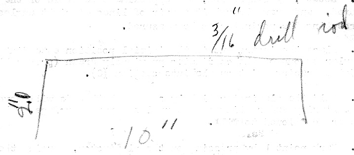
Figure 1. (This drawing was on the back of
the type written page in pencil. Figure 1?)
shows the planimeter more clearly than it can be described in equal space.
It is extremely simple to make. The only critical points to be considered
are that the instrument should be rigid, the two legs should be approximately
in the same plane and the "hatchet" edge should be kept sharp, razor sharp
for best results. Drill rod, three sixteenths inch in diameter, is
a convenient and satisfactory material. It can be tempered and is
not too difficult to work.
The distance AB can be any convenient length. Ten
inches is satisfactory for ordinary use and simplifies computations of
the moving of the decimal point. It is best to heat the drill rod
to a dull red in order to bend it. Too much heat will cause it to
crack. To operate the Hatchet Planimeter proceed as follows:
Place the figure to be planimetered on a flat surface
covered with paper having an unglazed surface. The flared point of
the instrument rides freely over the unglazed paper, while the operator
traces the outline with the opposite point of the planimeter.
In sequence the detailed manipulations are as follows: (Refer to figure 2) (figure 2 is missing)
1. Locate, by inspection, the approximate centroid of the
figure to be planimetered, and draw through it a pair of lines at right
angles of each other, and intersecting the perimeter to be measured.
2. Place the instrument in the initial position
extending approximately perpendicular to one of the coordinates previously
drawn (preferably the longer one), and the tracing point on the intersection
(O).
3. Hold the planimeter lightly so that both ends
will move freely over the paper, the flared end resting on the unglazed
paper surface. The instrument should never be allowed to tilt.
4. Mark point L by pressing on the planimeter, forcing
the sharp edge lightly through the paper.
5. Trace along line OA and around the perimeter
in a clockwise direction returning to O along AO.
6 Mark point M by pressing on the flared end
of the planimeter.
7. With the hatchet at M and the point held firmly
on O, rotate the figure through 180 degrees. The instrument should
not be allowed to shift its position, nor should point O change its
relations to M and L.
8. Trace the figure a second time along OA, but
this time in a counter clockwise direction, returning to point O
as before.
9. Mark point N by pressing on the planimeter as
before (4 and 6). Points L and N will be close together, the distance
between them depending upon how accurately the tracing has been done.
If points L and N coincide exactly it indicates that the tracing has been
exact. This rarely occurs but the area is corrected by measuring
the distance from M to point half way between L and N. A steel scale
calibrated to one hundredths gives acceptable results.
10. Multiply the distance obtained in operation
9 by the distance between the points of the planimeter (in this case 10
inches) to get the area of the figure measured. For greater accuracy
the distance should be measured on an arc with a radius equal to the distance
between the planimeter points. When ML is small the error due to
use of a straight scale will be negligible, however.
It is advisable to practice on conventional figures such
as squares, triangles and parallelograms with known dimensions until one
has developed some skill in holding the instrument lightly and tracing
accurately the outlines and figures. In practice it is advisable
to use as a corrected distance the average of three or more readings.
This reduces the affect of mechanical errors in holding the instrument,
tilt, and etc.
footnote: (J Scott 1998) The "regional office staff probably refers to the U.S. Soil Conservation Service Civilian Conservation Corps where Walter worked from April 37 to Jan 42. Walter owned a nice issue of the hatchet planimeter which I remember him showing to visitors to the farm. He showed me how he used it on aerial photographs to measure acreage of farmland.